http://farm3.static.flickr.com/2042/223 ... 4bcc_o.jpg
the painting was made from further west, to incorporate the hills etc.....unless Falkor is right about it crossing the tracks...(but I hope not...not at this stage, anyway)
so it seems to bear out the more westerly route
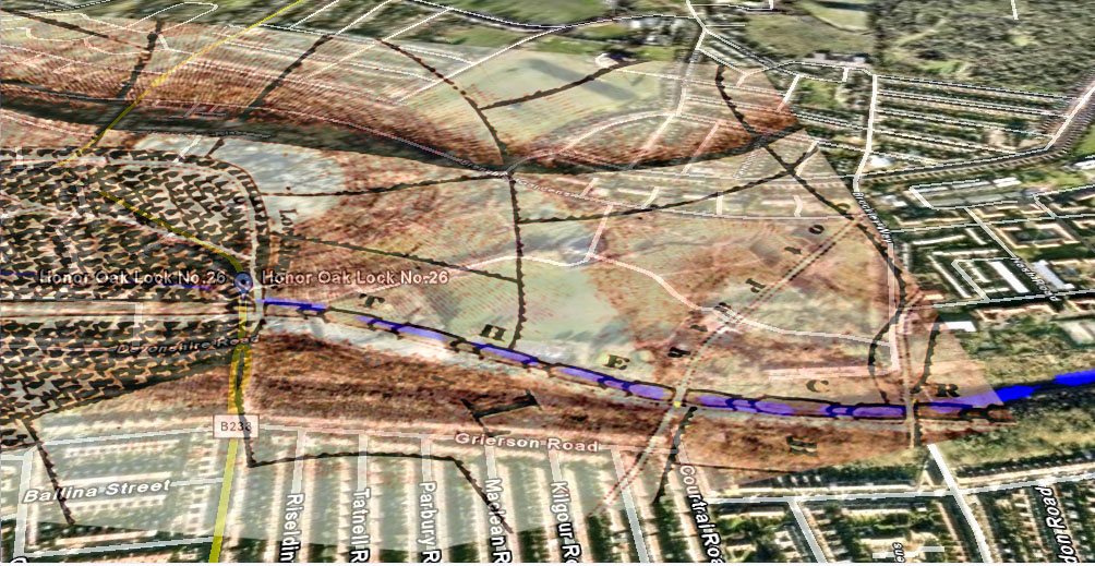
Croydon Canal route: Honor Oak Park to Brockley
I'm starting to believe it might not be so innaccurate afterall. Judging by the "official" maps, the canal seemed to leave Honor Oak Park more to left of the blue line and had more of a sharper curving shape at the railway similar to that estate map. Perhaps if the light blue and orange were moved slightly to the left to match up with the red then it might be more closer to the true alignment. I reckon it's not that far off. I think the locks seem correct as well? The "official" maps do show varying distances between each one, which I think is the parts you are referring to as "pounds"? Again, those maps did line up quite well. I'm starting to think that the website and "Retracing Canals.." book might have interpreted this section slightly wrong and out of shape. The canal could have met the railway as early as "dead lane"; it seems to have hit the embankment around the tennis courts. Sorry to be the devil's advocate, but I wouldn't assume either of us are right. I might have taken half those photos for nothing, and my captions may not reflect the true course of the canal, but finding out the truth is more important. I don't care if I end up proving myself wrong. Anyway, I think we're definitely getting closer, but still need to do more research into this horrid section and gather more accurately copied maps.doesnt look quite right to me...
perhaps its not as accurate as you expected...the length of the pounds aredifferent, so your allignment might be off.

-
will greenwood
- Posts: 352
- Joined: 14 Jan 2008 23:45
- Location: moorlinch
That fits with the image of the locks cutting along the side of the natural escarpment...
if we can pinpoint one actual spot...we can pace out the locks from the distances in the book...albeit roughly.
if you look where the path bends at dead lane and brockley way, it does imply a bridge further east, as you say...i reckon you 're on the right track here....
i'll amend it on the map and have a look
-
will greenwood
- Posts: 352
- Joined: 14 Jan 2008 23:45
- Location: moorlinch
-
will greenwood
- Posts: 352
- Joined: 14 Jan 2008 23:45
- Location: moorlinch
I imagine the locks would have been dug out completely on the eastern slopes, possibly leaving bits of the western banks.
the higher locks may be simply filled and left...they would have compressed the earth and raised a mound to allay subsidence...
if the embankments were sound, they may well have simply filled and packed and used the natural slope, at least at the top.
the higher locks may be simply filled and left...they would have compressed the earth and raised a mound to allay subsidence...
if the embankments were sound, they may well have simply filled and packed and used the natural slope, at least at the top.
-
will greenwood
- Posts: 352
- Joined: 14 Jan 2008 23:45
- Location: moorlinch
http://farm3.static.flickr.com/2358/223 ... 0f19_o.jpg
http://farm3.static.flickr.com/2344/223 ... c644_o.jpg
http://farm3.static.flickr.com/2123/223 ... 07df_o.jpg
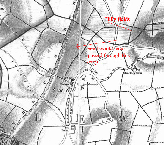
...interesting..
the main escarpment of the cutting near honor oak does seem to be contemporary with the canal...and the 1833 map lines up more or less with with the new course you plotted...
I'll try to draw a 3d version of the locks going downg the scarp...
http://farm3.static.flickr.com/2344/223 ... c644_o.jpg
http://farm3.static.flickr.com/2123/223 ... 07df_o.jpg
...interesting..
the main escarpment of the cutting near honor oak does seem to be contemporary with the canal...and the 1833 map lines up more or less with with the new course you plotted...
I'll try to draw a 3d version of the locks going downg the scarp...
-
will greenwood
- Posts: 352
- Joined: 14 Jan 2008 23:45
- Location: moorlinch
heres a rough sketch in 3d (ish)...
the 1833 map shows the top 3 locks apparently dug in to flat iis ground, with the ground tapering away to the north east at lock 23.
from here, the canal would be likely to have been cut into an an embankment as it hugged the hillside,
the towpath and the bank would appear stepped as it followed the locks down.
also, the triangular feature I misidentified as lock feeder is also apparent just past the top lock...and marks the boundary of the burial ground today.
it could have been cut for a wharf or yard that never held water., but it is certailny very reminiscent of a winding hole or boatyard / wharf..perhaps before 1833...(I'm sure I've seen it on a map in water...but I may be wrong
http://farm3.static.flickr.com/2336/223 ... 3abe_b.jpg
it does seenm to bear out the more easterly line.
Mate, you'll have to give me some time to take all this in... Hey, for a wonderful surprise, have you checked Steve G's flickr space? I was checking out a similar view published in a John Coulter/John Seaman book last night, and thinking of trying to get an upgrade from Lewisham Local Studies. I want to find out the history of the aforementioned mounds...
http://www.flickr.com/photo_zoom.gne?id ... 767&size=o
http://www.flickr.com/photo_zoom.gne?id ... 767&size=o
-
will greenwood
- Posts: 352
- Joined: 14 Jan 2008 23:45
- Location: moorlinch
Does the painting showing Shooters Hill also seem to show a large mound rising to the left? I don't think there's any hills to the left of Shooters, so it could be that large mound, which might predate the railway cutting. Today, we was discussing what might have become of all that earth? Looking at the terrain, does it at all seem possible to you that the playing fields might have been levelled with spoil? I don't notice any steepness leading up to the banks; it's just a flat ground with a sudden terrifying drop down to the railway line. Therefore, I believe the canal and locks cannot be located too far down underground.
-
will greenwood
- Posts: 352
- Joined: 14 Jan 2008 23:45
- Location: moorlinch
i think the playing field was almosrt certainly levelled off with spoil...especially nearer the brockley way end, where there seems to be a distinct valley....
the canal cutting may be only a few feet underground by the top lock, but, obviously will get 3 -6 feet deeper at each lock, so, unless we could access from the embankment, we are looking at a dig of up to 24 - 36 feet, plus spoil, by the time it gets to lock 23 where it hits the present cutting.
best places for a 'light' dig must be those mounds, and the higher area near top lock...the towpath might leave some traces, as the stepped nature of it could be spottable....
I deally, the railway side of the top of the cutting is the ideal spot...i'm sure now it was there at the time.
as for the mound on the painting...interesting!
as you say, theres no hill that size, or that side of the canal.....its too big, and apparently too far away to be spoil...posibly 'artistic licence'...maybe he brought hilly fields closer?
....also, the top area between the mounds is higher than it was, so that has been filled in too, i think.
-
will greenwood
- Posts: 352
- Joined: 14 Jan 2008 23:45
- Location: moorlinch
heres a section from the 1833 map.
http://farm3.static.flickr.com/2211/223 ... 68f9_o.jpg
the only real possibilty for that 'hill' in the painting is the other side of the (natural') vale which was deepened for the cutting....
'possibility' is all it is though..
(I reckon the artist ran out of ideas, or paint, and simply addded a hill to frame the scene)
Do you know of any other maps that show the canal and its environs, particularly through forest hill?
-
will greenwood
- Posts: 352
- Joined: 14 Jan 2008 23:45
- Location: moorlinch
sorry to keep filling up the thread with my wanderings......
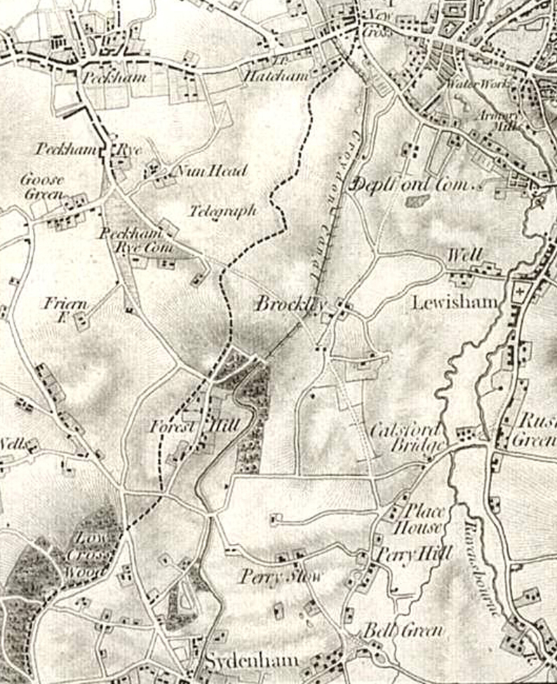
heres a section from an 1820's map of south london, i think, showing the canal in situe...
http://farm3.static.flickr.com/2240/223 ... bd1c_o.jpg
heres a section from an 1820's map of south london, i think, showing the canal in situe...
http://farm3.static.flickr.com/2240/223 ... bd1c_o.jpg
Well spotted re: hills/banks on the 1833 map! I never would have noticed that unless you mentioned it. You're really starting to squeeze every bit of remaining information out of the available maps. It's added another dimension to this discussion, so then, allow me to step back for a bit to have a re-think. I never imagined the canal already being situated on banks... this topic is becoming very high level indeed. If only somebody could disprove my hypothesis about the canal reaching what is now the eastern bank of the railway...otherwise it remains the most accurate--based on the estate map corroborated with the rough copies of the "official" maps--I see you've already updated this stretch on Google Maps; good job, Will!
-
will greenwood
- Posts: 352
- Joined: 14 Jan 2008 23:45
- Location: moorlinch
Good job, yerself, mate.....
its great to be able to 'debate' such a project....i'd have missed those estate maps, for sure!
I have a feeling this is the most accurate course to date...
.... it does make sense...with brockley road known as brockley 'vale', that the area was very different...ie, the swing bridge was ...well, in a vale!!
.......and it does bode well for the eventual discovery of a lock or 2...but only with permission from the railways...(.which wont be easy..)....
if you look at the painting of the top lock...you'll notice a gentle slope , rigjht to left....i think this is the kind of inclination that has been levelled of...until the embankment.....what we really need is accurate contour data of the area...
also...do you , or anyone know where to get wartime aerial photos from the big national survey?
I'm sure a lot could be gleaned from pre crematorium and allotments images..
anyway, given the time, and a free hand, i'm sure we can find something to pin this down once and for all...
Good thinking, again! I never thought about looking for an early aerial photo of Honor Oak Park. I know WW1 photos exist for Catford and Crystal Palace, whereas the earliest for Upper Sydenham is from the 1960s with the exception of a newspaper article posted by Steve Grindlay last year. I even asked John Coulter @ Lewisham Local Studies, but he said he hadn't come across any Upper Sydenham aerials from WW1 or WW2 time either, but as for Honor Oak, I'll look into it...
-
will greenwood
- Posts: 352
- Joined: 14 Jan 2008 23:45
- Location: moorlinch