...printing error...it was 570 feet!
the swing bridge at Vesta Rd
........but he does still seem to be describing that image....a bit confusing this one.
It could be at the top of the railway cutting behind Vesta Rd...thsi is more likely, I reckon.
Pictures of the Croydon Canal
Good job, Will! I still plan to check how accurate your section is on Anerley using the 1837 enclosure map + 1852 Crystal Palace Estate map. There really is no hope of confirming the accuracy of the Brockley section, including the exact location of the locks--my maps just aren't good enough--though I still think some of those estate maps may come in handy if I ever get round to ordering them. Anyway, keep up the good work, mate!
Thanks Steve! Shame nobody knows where that fine painting is kept...
Stewart Marchant, hello sir, and welcome to the forum! That picture of the swing bridge, including the caption, was scanned from a book about Penge by David R Johnson. Is he correct about his information? I don't know, since I haven't yet got round to researching the number of swing bridges and their locations. [This book], the most authoritative account of the history of the Croydon Canal, should confirm whether he was right and provide you with the necessary information. In researching that book, I'd imagine the primary source used by the authors would have been these [maps]. No Ordnance Survey maps will show the canal other than remnants; same with the 1843 Tithe maps. This is what makes Will's job so tough. We have to rely on Kent county maps, specialised London maps and misc. estate maps. Accuracy is a big problem. It might be possible to ascertain where all the major road bridges occurred along the canal, but establishing the location of all minor swingbridges may prove more difficult. This website does a great job utilising other methods and research techniques, making use of surviving physical evidence to help indicate the canal's former alignment and location of features:
http://www.londoncanals.co.uk/croydon/ccintro.html
-
will greenwood
- Posts: 352
- Joined: 14 Jan 2008 23:45
- Location: moorlinch
Cheers Falkor.Good job, Will! I still plan to check how accurate your section is on Anerley using the 1837 enclosure map + 1852 Crystal Palace Estate map.
Indeed!
both this section and the New Cross section still need work...
and then theres the croydon end...
but a pictutre is certainly developing[/quote]
-
will greenwood
- Posts: 352
- Joined: 14 Jan 2008 23:45
- Location: moorlinch
I've just had an interesting email...
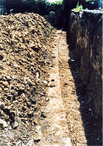
...it may be possible to get access to the site of the boat yard inlet and the reed bed sections of the canal in Devonshire rd nature reserve, for a bit of a root about..if you're interested, Falkor....
I am particularly intrighued by what my be extant where the boathouse was....it seems to have been more or less left alone since before the railway cutting.
...perhaps we'll find something...who knows?
Yeah, I'd be interested in that mate... What about coming for a dive at Dacres Wood Nature Reserve? You travelling east for the Forest Hill talk on Wednesday, Will? I look forward to meeting you sooner or later...
I found a place for us to dig where we will never be disturbed! What about the site of the Penge Wharf? Plus, did I hear it used to be site of the first Penge train station or something? We can come and go when we like.
I found a place for us to dig where we will never be disturbed! What about the site of the Penge Wharf? Plus, did I hear it used to be site of the first Penge train station or something? We can come and go when we like.
-
will greenwood
- Posts: 352
- Joined: 14 Jan 2008 23:45
- Location: moorlinch
-
will greenwood
- Posts: 352
- Joined: 14 Jan 2008 23:45
- Location: moorlinch
I'd love to see Steve's talk and meet up, sadly, I'm a bit out of commision till I heal up a bit more...
but , yes...I cant wait to actually see these places again, its been a few years now...and I've got a whole new take on the area since I started delving again.
I'm well up for supervising any diving you wish to undertake....from the towpath, I reckon,.....with the tea.
but , yes...I cant wait to actually see these places again, its been a few years now...and I've got a whole new take on the area since I started delving again.
I'm well up for supervising any diving you wish to undertake....from the towpath, I reckon,.....with the tea.
-
will greenwood
- Posts: 352
- Joined: 14 Jan 2008 23:45
- Location: moorlinch
This does have the shape and scale to fit the bill.
whereas a lot of the canal would have been simply grass embanked, around the swing bridges, there would have been facing like this.
It does imply the area to the right of the stones is the course of the canal itself....
I believe, from memory it was about the right distance from the present footpath to be the correct width...
-
will greenwood
- Posts: 352
- Joined: 14 Jan 2008 23:45
- Location: moorlinch
Living as I do along side an active canal, I would venture to suggest that those stones may be the edge of a lock or wharf.
Towpaths are seldom edged unless in those two areas of activity.
If I am right, under those stones should be courses of brick
I'm not sure if I have the right place, is this at the bottom of Clyde Vale?
By the pub at the top of Clyde vale, there used to be a set of railings; beside these railings, until the 1970's at least was a large square post, with a metal cross piece; this had areas of deep grooving obviously caused by rope wear. It was told to me that this post was a relic of the canal, where boats used to be hitched to.
-
will greenwood
- Posts: 352
- Joined: 14 Jan 2008 23:45
- Location: moorlinch
yes, I agree.
The Dartmouth Arms would have had moorings so near the bridge, at a junction, but there is nothing on the maps to suggest a wharf of any size.
I agree about the course of bricks/ stones under the facing stones.
Interesting to hear about that post...I wonder if anyone else has anything on that.
The Dartmouth Arms would have had moorings so near the bridge, at a junction, but there is nothing on the maps to suggest a wharf of any size.
I agree about the course of bricks/ stones under the facing stones.
Interesting to hear about that post...I wonder if anyone else has anything on that.
BTW, you realise that the Dartmouth Arms and the Bird In Hand pubs were both open during the time of the canal? Honor Oak Road seemed to have major development work happening during these times. Before the railway cutting, there used to be a thick vertical layer of woods in the Devonshire Road area, lining the northwest of Stanstead Road up to Honor Oak Park.* Around the time the 2 Dartmouth Road pubs opened (1814-1816), when Honor Oak Road (the original Forest Hill) was just getting started, there was also built a small set of cottages in the northwest corner of Stanstead Road called Eliza Place. These aforementioned buildings are some of the earliest after Sydenham Common became enclosed about the same time the canal opened. Anyway, you can begin to build up a picture of how the area looked and developed during the time of the canal (post enclosure).
*This section of the canal was called Forest Wood.
*This section of the canal was called Forest Wood.
Last edited by Falkor on 28 Jan 2008 22:54, edited 1 time in total.
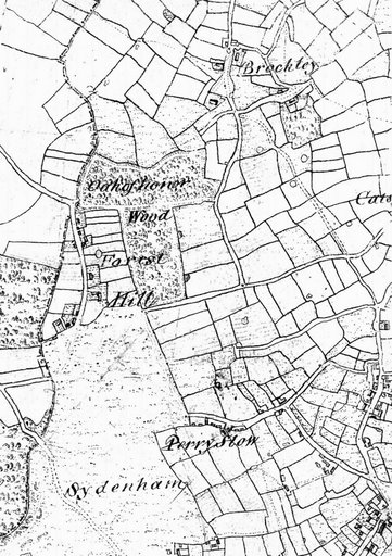
Compare these maps by publication date: (left=1816; right=1829)


*Vertical stretch of woods is clearly visible above Stanstead Road
*Early post-enclosure settlement in Honor Oak Road, Stanstead Road (Eliza Place), Round Hill and Perry Vale areas.
*Honor Oak Road went on to become majorly developed.
*3 black dots between Dartmouth Road and Croydon Canal indicates 3 buildings there during the time of the canal, which included the 2 aforementioned pubs.
-
will greenwood
- Posts: 352
- Joined: 14 Jan 2008 23:45
- Location: moorlinch
-
Steve Grindlay
- Posts: 606
- Joined: 4 Oct 2004 05:07
- Location: Upper Sydenham
I agree about the Dartmouth Arms, which was first licensed in 1815, but I'm not so sure about the Bird in Hand. The earliest reference I have come across for that was as a beer house in 1845, when Jonathan Rayner was the tenant.Falkor wrote:...you realise that the Dartmouth Arms and the Bird In Hand pubs were both open during the time of the canal?


-
will greenwood
- Posts: 352
- Joined: 14 Jan 2008 23:45
- Location: moorlinch
i'm glad you put that image in....i'd forgotten that view.
well...it could be the dead lane lock (number 22)...it certainly looks like one tree hill...however...
I dont think there were ever houses on one tree hill, and itappears too close to the canal...
I reckon its artistic licence again...its near the top lock, towards the house (lockkeepers coottage) you photographed, but about 10 - 15 feet lower, looking up towards forest hill road and the big houses there...just made bigger and garander by the artist....so...it could be lock 24 0r 25, near the mounded enclosure