Does anyone know of an image of the railway bridge over Forest Hill Rd at Brenchley Gardens, or any views of the Crystal Palace High Level line between the old Honor Oak Station and Nunhead.
Also;
Are there any views of the old Observatory at the junction between Forest Hill rd and Honor Oak Rd?
(or any contemporary views of that area)
Brenchley Gardens Railway Bridge...and area
-
will greenwood
- Posts: 352
- Joined: 14 Jan 2008 23:45
- Location: moorlinch
-
will greenwood
- Posts: 352
- Joined: 14 Jan 2008 23:45
- Location: moorlinch
well, heres one, to start with...
at the end of Brenchley Gardens, before demolition.
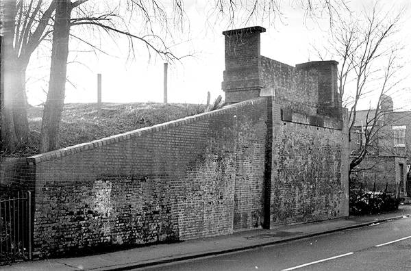
at the end of Brenchley Gardens, before demolition.
Last edited by will greenwood on 10 Feb 2008 16:36, edited 1 time in total.
-
will greenwood
- Posts: 352
- Joined: 14 Jan 2008 23:45
- Location: moorlinch
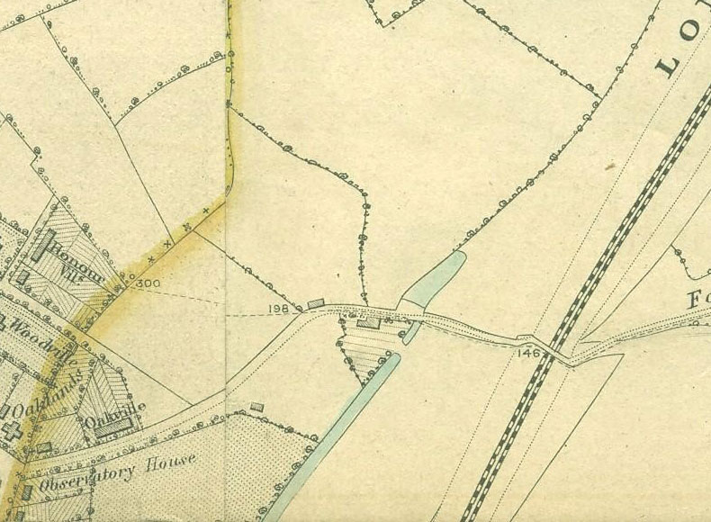
On all the older maps I've seen, there is an Observatory marked at 'Observatory house, on the corner ofHonor Oak Rd and Forest Hill Rd.
here are a few examples
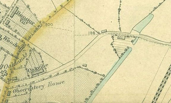
here are a few examples
Last edited by will greenwood on 10 Feb 2008 16:37, edited 2 times in total.
-
will greenwood
- Posts: 352
- Joined: 14 Jan 2008 23:45
- Location: moorlinch
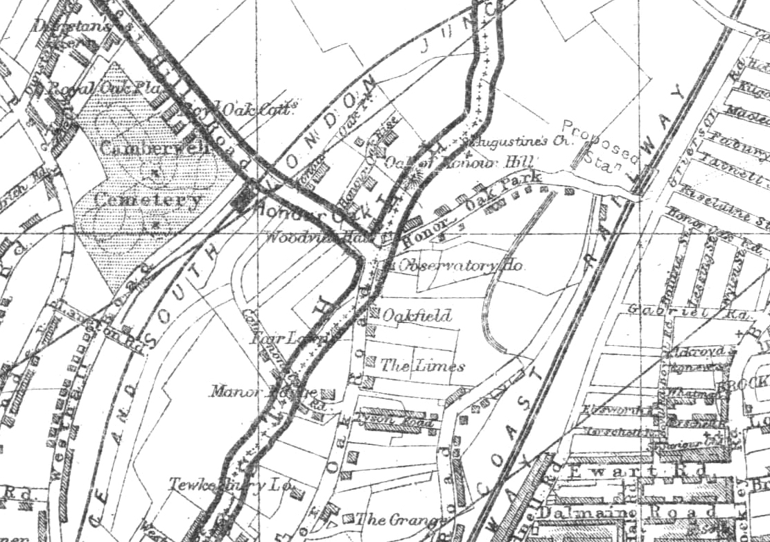
The last of Will's maps is interesting.
It seems to show an overlay of an old road following the kent surrey boundary.
An extension of what is now the straight part of Horniman drive, cutting across Canonbie Rd, crossing Honor Oak Pk and up past the actual tree of honor, has merit. Perhaps it met up with Ivydale Rd on the other side of Brenchley Gardens, (long before the railway came and went).
The tree (that Liz honored), being off the beaten track, has always struck me as odd, along with st Augustine's just hanging there. Plus you imagine that there would be a path along such a major boundary.
Except I've never seen any old map describing such a Road. A road joining the hills (one tree, horniman, Sydenham hill?) was a Roman trick to reduce ambush so it could be a very old track.
Sorry to ambush the thread, but I love old maps!
Was there such a road?
-
will greenwood
- Posts: 352
- Joined: 14 Jan 2008 23:45
- Location: moorlinch
Hi Perryman,
Im afraid I cant find the original of that map, so I cant remember the significance ofthe enclosed area, although I suspect it was simply to mark the county boundaries.
looking at these older maps, it would seem that field boundaries marked this 'route', so its not impossible that it would have been a very old 'green' track
perhaps Steve Grindley can help further.
-
will greenwood
- Posts: 352
- Joined: 14 Jan 2008 23:45
- Location: moorlinch
...I think you'e probably right.
Certainly, One tree hill would have been an important viewpoint and likely strategic position, (as told in the legend that Boudicca and her band camped there before sacking London c.60 AD)
it would be interesting to see if there is any sign of that route at all in the present, although much would be in the convent gardens .
there is of course the remains of an old track that runs down the side of the cemetery fence to the gate on brenchley gardens, so it isnt beyond the bounds of possiblity that we have mislaid one.
-
will greenwood
- Posts: 352
- Joined: 14 Jan 2008 23:45
- Location: moorlinch
I think this will prove interesting as well, for this subject and others;
http://www.archive.org/stream/storyofon ... h_djvu.txt
http://www.archive.org/stream/storyofon ... h_djvu.txt
What a great read - the text version is a little scrambled but the (large) pdf version is fine.
I had not realised how old Wood Vale was - I knew it was amongst the oldest roads leading into the area - but the romans using it in battle is a great surprise.
If there was a significant path at the top of the hills back then, the romans surely would have used that instead - I think I will have to concede that any hypothetical road along the hill tops/county boarder was after the romans.
-
Steve Grindlay
- Posts: 606
- Joined: 4 Oct 2004 05:07
- Location: Upper Sydenham
On a personal note, I can't resist mentioning that the author of this booklet was my great grand-father, John Nisbet. He was a Camberwell councillor, and one of the leaders of the campaign to keep One Tree Hill an open public space. He is mentioned on the plaque at the foot of the oak tree that he helped plant.
Perryman, I wouldn't believe that stuff about Boudicca. Remember, John Nisbet was involved in a campaign to potect the hill from developers. Under such circumstances perhaps he can be forgiven for slightly stretching the truth. It is generally accepted that the site of her final battle is somewhere to the north of London (I can't remember where, offhand).
As for your theory about a track (it could have been no more) along the ridge of the hill, I actually think that is possible. Such prehistoric tracks, following the ridge of a line of hills, known as ridgeways, survive in other parts of the country.