Croydon Canal exposed!!! (Anerley, Penge)

The History of Sydenham from Cippenham to present day. Links to photos especially welcome!
Post Reply
Falkor
Posts: 1371
Joined: 10 Feb 2006 17:45
Location: Surrey Quays

Croydon Canal exposed!!! (Anerley, Penge)

Post by Falkor »

I was quite shocked and surprised today to come across the following spectacle at the side of Anerley train station, on the site of the former Anerley Arms tea gardens.

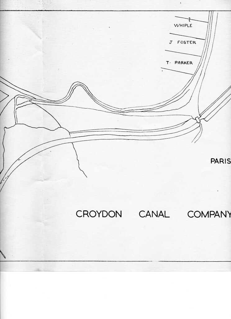
It turns out that, about a year ago, when a school was demolished at the back of Anerley Park, these long trenches (pictured below) were dug out and left! That's what the locals told me. Obviously, the workmen had discovered remains of the Croydon Canal / towpath!!!
Image

Image

Image

Image

Image
This is really quite incredible! How could this evidence have gone unreported for so long!?

Image

Image

Image
I reckon the alignment could be slightly more to the right...

Image
Green or blue could be the most accurate I reckon!

Image
This bank is blatantly connected to the canal--ran underneath that building to the right--so is of the canal cutting.
peter coppin
Posts: 24
Joined: 25 Mar 2008 08:08
Location: honor oak - forest hill

croydon canal

Post by peter coppin »

Hi

I`ve looked with intrest at all you have said about the route of the croydon canal, and looked at various write-ups. The New Cross area is a minefield and from my view incorrect as it appears that the canal ran alongside the railway making it further west. But I`am Jumping the gun you have not got to this part as yet. So Turning to Forest Hill. I feel that the triangle in the fieldings (off manor mount ) represents the canal pond on old maps at the top of Davids Road and appears also to have been a minor reservior as indicated on those old maps - making the canal higher up than is assumed.

Forthermore some 20 years or so back the News Shopper was running articles on local history where it suggested that the site of the old capital pictures, where the road widens and the ground cut back into the hill, was indeed a dock head.

Whilst at the new cross end again there was indeed a resevior at telegraph hill which is possible a minor feeder for the canal as there were no water companies around until after the canal closed - although it is noted that the canal was to be used as a source of water for forest hill - just food for thought.

Bye the way well done thus far.
will greenwood
Posts: 352
Joined: 14 Jan 2008 23:45
Location: moorlinch

Post by will greenwood »

Hi Peter..
I think the OS maps show quite clearly where the canal ran, and it would have needed locks to rise to the level of the cinema, as it ran as close to one contour as possible.
I'd like to know why the hill was cut into, but it certainly wasnt for the canal, altough there was a stream that ran along London Rd roughly in front of the cinema.
check out the other canal posts for all the maps.
peter coppin
Posts: 24
Joined: 25 Mar 2008 08:08
Location: honor oak - forest hill

croydon canal

Post by peter coppin »

Hi will

Your the expert

I am aware of the stream that ran past the cinema - but why the cutting into the bank? - accepting that news shopper got it wrong.

Going back to the pond on the old maps - at the entrance to the fielding there is an unused triangle grased over which appers to be the same as the triangle shape of the pond - forgetting any rise in gradient from davids road - is it not questionable.

Kind regards
peter
will greenwood
Posts: 352
Joined: 14 Jan 2008 23:45
Location: moorlinch

Post by will greenwood »

Hi
I've had a good look, and the fieldings is much higher than the canal was, and the triangle of grass is much smaller than the area in question.
take a walk down to the ambulance station...the low triangular area biordered by Pearcefield rd is the area of the pool, with the canal heading off along Halifax st to the south, and north east by the back of the old church...in fact it is possible that the steep bank behind the chapel is part of original embankment of the canal.
As for the cinema...I am intrigued as to why such a massive cut was made into the hill just for the pictures...
I'd like to know what thats about, certainly....it was something important.
I'll have a look at some maps.
Falkor has done some good work about the streams and feeders for the canal elsewhere here.
peter coppin
Posts: 24
Joined: 25 Mar 2008 08:08
Location: honor oak - forest hill

croydon canal

Post by peter coppin »

hi will

Again you have proved what an expert you are on the subject. - however i am still intrigued why such a triangle of land has been left at the fieldings - where the whole curveature of the road appears to mimic the route of the canal.

That said - why is the route of the canal so poorly documented

peter
will greenwood
Posts: 352
Joined: 14 Jan 2008 23:45
Location: moorlinch

Post by will greenwood »

I've been checking some new maps of the Canal, supplied by Steve...
I reckon there was a small mooring/wharf directly south of the swing bridge at the Dartmouth Arms..perhaps just long enough for 2 or 3 narrowboats, roughly where the pub Yard is...perhaps the recently exposed bank constituted part of the mooring.
there is also a hint of a footpath/towpath along the western bank as far as Clyde vale or so.
here is an early map, showing a rough inlet;
Image

...and here its been tidied up;
Image
Post Reply