Bell Green
Bell Green
I have been showing this site to my mum recently and she was wondering if anyone knows the history behind 'Bell Green'? Why is it called Bell Green? My mums thinks that a bell used to sound at certain intervals during the day to signal the workers that lived locally. Not sure if this is true. Does anyone know any more? Any photos? I think there used to be some 'quaint' work mens cottages near the gas works site - any photos of these?
I think if I remember rightly the local history books say the area got its name from a pub called 'The Bell' . I don't think it said why the pub was called the Bell.
There is still a pub in that vacinity called the Bell but I think the books say there was an older one previously and not exactly in the same location. Hopefully I might find which book it was in and let you know.
There is still a pub in that vacinity called the Bell but I think the books say there was an older one previously and not exactly in the same location. Hopefully I might find which book it was in and let you know.
-
Steve Grindlay
- Posts: 606
- Joined: 4 Oct 2004 05:07
- Location: Upper Sydenham
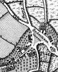
Bell Green was at one time known as Sydenham Green, and was indeed the village green. This map shows it in 1745:
and this map shows the green in 1799:
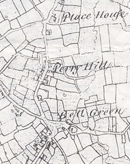
It is clear that sometime between these dates the name changed from Sydenham Green to Bell Green.
During the 18th century much of the land around Bell Green was still farmland. One farmer, Nicholas Stevens, combined farming with running an alehouse during the 1750s. He called his alehouse the Bell. Although the Bell alehouse had a fairly short life (the land on which it stood was sold in the 1770s and it was demolished soon after) it was clearly an important building on the village green. It would have been on the gasworks site, probably within the fenced-off area between the gasholders and the present Bell Inn (which was built about 1843 and first licensed in 1844).
John Coulter says, in Sydenham and Forest Hill Past: "Fanciful theories have been put forward to explain how the name Bell Green came to replace Sydenham Green in the second half of the eighteenth century. The prosaic truth is almost certainly that it was called after the Bell alehouse, which was its most prominent building. The name undoubtedly belonged to the pub before it was transferred to the green."
The "fanciful theories" referred to were recorded in History of Kent (ed. Henry Drake, 1886). This says: "Bell Green is said to have derived its name from a tower on it in which a bell signalled the approach of any visitor to Place House". Place House was at the opposite end of Perry Hill, in Elm Lane, near the junction with Vancouver Road and Catford Hill (it is shown in the 1779 map above). The story is that Elizabeth I made regular visits her favourite, the Earl of Essex, who was supposed to have lived there. To warn him of her approach and give him time to hide his wife, the bell on Bell Green was rung. Although a couple of courtiers from the Royal Palace at Greenwich lived in Place House and Elizabeth I visited the house, there is no evidence that the Earl of Essex was one of them, or that the queen made clandestine visits.
and this map shows the green in 1799:
It is clear that sometime between these dates the name changed from Sydenham Green to Bell Green.
During the 18th century much of the land around Bell Green was still farmland. One farmer, Nicholas Stevens, combined farming with running an alehouse during the 1750s. He called his alehouse the Bell. Although the Bell alehouse had a fairly short life (the land on which it stood was sold in the 1770s and it was demolished soon after) it was clearly an important building on the village green. It would have been on the gasworks site, probably within the fenced-off area between the gasholders and the present Bell Inn (which was built about 1843 and first licensed in 1844).
John Coulter says, in Sydenham and Forest Hill Past: "Fanciful theories have been put forward to explain how the name Bell Green came to replace Sydenham Green in the second half of the eighteenth century. The prosaic truth is almost certainly that it was called after the Bell alehouse, which was its most prominent building. The name undoubtedly belonged to the pub before it was transferred to the green."
The "fanciful theories" referred to were recorded in History of Kent (ed. Henry Drake, 1886). This says: "Bell Green is said to have derived its name from a tower on it in which a bell signalled the approach of any visitor to Place House". Place House was at the opposite end of Perry Hill, in Elm Lane, near the junction with Vancouver Road and Catford Hill (it is shown in the 1779 map above). The story is that Elizabeth I made regular visits her favourite, the Earl of Essex, who was supposed to have lived there. To warn him of her approach and give him time to hide his wife, the bell on Bell Green was rung. Although a couple of courtiers from the Royal Palace at Greenwich lived in Place House and Elizabeth I visited the house, there is no evidence that the Earl of Essex was one of them, or that the queen made clandestine visits.
-
Steve Grindlay
- Posts: 606
- Joined: 4 Oct 2004 05:07
- Location: Upper Sydenham
I think two stories have merged here. Several historians claim that George III visited the medicinal springs on Sydenham Common (near the junction with Taylors Lane and Wells Park Road). They give no date, but apparently he spent "the best part of a day whilst he drank the waters".sarahc wrote: ... I have heard about royalty visiting before - but I heard that it was a King (not sure which one!) and that he used to visit his mistress in Sydenham ...
An alleged Royal visit involved his son the Duke of Clarence, later William IV. There is a plaque on Ashberry Cottage, 62 Honor Oak Road, that claims that "Here lived William Duke of Clarence ... and Mrs Dorothea Jordan actress". Unfortunately, there is no evidence to support this claim. Furthermore, documentary evidence suggests that the cottage was built in the 1820s, and Mrs Jordan died in 1816.
On the other hand, there has long been a legend that Elizabeth I "went a mayenge to Sir Richard Buckley's at Lewisham". The story has it that she rested under an oak tree on One Tree Hill. Her movements round the country were carefully recorded in a Court Calendar, and the entry for May 1 1602 has "A visit to Sydmondscourt, Lewisham, Sir Richard Buckley". Other records show that Sir Richard Bulkley was the tenant of Place House from 1602-1612. It is possible that, as a guest of Sir Richard, she spent this May Day on One Tree Hill. From at least 1719 the oak under which she allegedly sat was known as the the Oak of Honor or Honor Oak.

-
Steve Grindlay
- Posts: 606
- Joined: 4 Oct 2004 05:07
- Location: Upper Sydenham
I think you're right. According to John Coulter (Sydenham & Forest Hill Past) the original Bell was licensed from the 1720s until 1778. It should, therefore, appear on this map, which was surveyed about 1745. Also in John's book (on page 17) is an estate map of c1800. On this map John identifies "Bell Orchard" as the probable site of the pub. By comparing these two maps it is clear that buildings 1 and 2 are on Bell Orchard. What clinches it for me is that the footpath to the left of the field appears on both maps. Well done, Falkor. I now think the site today would be somewhere in the middle of Sainsbury's carpark.
That map on page 17 is extremely difficult to interpret... I've analysed it dozens of times, but cannot make head nor tail of it... However, after you mentioned the footpath, I think I can begin to figure it out. I agree the Bell is probably inside one of those 2 circles, but it's probably impossible to know which one.


-
Steve Grindlay
- Posts: 606
- Joined: 4 Oct 2004 05:07
- Location: Upper Sydenham
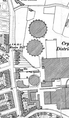
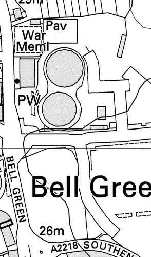
You are absolutely right, Falkor. Well done. Even in the 1894 OS map the outline of this plot can still be seen, between the surviving gasholders and Perry Hill. Although, on the modern map, much of the boundary has been lost it does seem as though the northern (top) boundary survives, as has the line of the Claremont path.