Another website ( http://www.flickr.com/photos/yersinia/3061328430/ ) has made the bomb damage maps for London available. Unfortunately they are not of sufficiently high resolution to make out some of the finer detail so I've uploaded the relevant maps from my copy of the book. I'd previously been reluctant because I was unsure about copyright issues.
This is the link:
http://www.flickr.com/photos/stevegrind ... 445257235/
I've included the key explaining the significance of the colours and circles. Be aware, though, that downloading the images at original size might be slow.
Bomb damage maps
-
Howard Staunton
- Posts: 88
- Joined: 15 Sep 2007 18:30
- Location: Fairlawn Park
Steve,
Would it be possible for you to upload a bomb damage map that includes Fairlawn Park? Such a map was included in the following thread, but I was hoping for an image with a better resolution.
http://sydenham.org.uk/forum/viewtopic. ... d2379278e5##
Thanks in advance.
Howard
Would it be possible for you to upload a bomb damage map that includes Fairlawn Park? Such a map was included in the following thread, but I was hoping for an image with a better resolution.
http://sydenham.org.uk/forum/viewtopic. ... d2379278e5##
Thanks in advance.
Howard
-
Steve Grindlay
- Posts: 606
- Joined: 4 Oct 2004 05:07
- Location: Upper Sydenham
-
Howard Staunton
- Posts: 88
- Joined: 15 Sep 2007 18:30
- Location: Fairlawn Park
-
Howard Staunton
- Posts: 88
- Joined: 15 Sep 2007 18:30
- Location: Fairlawn Park
Steve,
At the risk of being extremely cheeky, I don't suppose you have any images of Fairlawn Park itself. I know this end of Sydenham Road seems not to have been very popular with the postcard producers of the early 1900's. I have only ever seen one such card, reproduced in the book 'Sydenham and Forest Hill' by Coulter & Seaman.
Thanks again.
Howard
-
Steve Grindlay
- Posts: 606
- Joined: 4 Oct 2004 05:07
- Location: Upper Sydenham
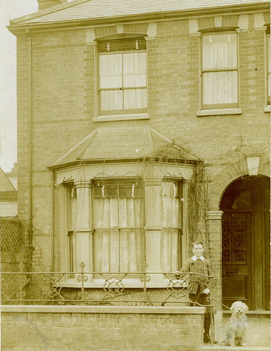
Unfortunately not, Howard. This is ironic given that one of the most prolific local postcard producers, Ernest William Garland, actually lived and worked in Fairlawn Park (at 26 East Terrace) between about 1905 and 1911.
Garland produced hundreds of postcards, mostly of modest terraced houses in Lower Sydenham, Penge and Beckenham. The view was always of a single house and usually had members of the family posing outside. Frustratingly there were rarely any clues to identify the building. Undoubtedly he would have taken pictures of his neighbours' houses, but I have yet to come across one.
This, not of Fairlawn Park, is a typical example :
-
Howard Staunton
- Posts: 88
- Joined: 15 Sep 2007 18:30
- Location: Fairlawn Park
Bomb Damage Maps
May I add a few comments to this subject?
Steve's picture depicting a bus is, without doubt taken from a point a few yards west of the junction of Sydenham Road and Kent House Road. I would hazard a guess that it was in the early twenties as I am confident that the bus was a number 75, a Tillings Steven petrol electric, there were only two services using that route through Sydenham at that time and the other was a number 2a (Lewisham the George to Golders Green via the Crystal Palace.)
Why a 75? well the Tillings buses of that era were narrower than the General Omnibus Company's wider buses which ran on the route 2a.
Closer examination of the pictire shows the Cathlic Church in the background where it was located on the corner of Watlington Grove, before it was bombed. Closer examination one can see the bell high in the bell tower.
On the left of the picture one can see part of the Wesley Hall high in the background, In the far distance one can make out the shop on the eastern corner of Fairlawn Park, Collingwoods the butcher,
In the middle of the junction one can also see a horse trough which was located in the middle of the junction and remaned there until after WW2.
Ther were many horse troughs located within Sydenham and Forest Hill, one at Bell Green, anothe just past Chalk & Cox butchers at the bottom of West Hill, another at the Woodman and another at Bell Green at the junctin of Perry Hill and Perry Vale.
A question has been asked regarding another picture taken from almost the same location as to whether it was WW1 or WW2. I can assure you that it was taken during WW2 as I can identify the street lights that can be seen. As a matter of interest, we were told when they were installed in the early 30's that they were an experimental test bed, as were a similar set installed in Stanstead Road Forest Hill. The very first fluorescent street lighting in the country.
They created quite a controversy with the womenfolk as they gave off a blue/green colour which played havoc with the ladies make up. They were very bright as compared with the gas lighting they replaced. The lamp post were very high and half way up there was and ordinary filament lamp installed that was automatically switched on at midnight to take over from the brilliant lanterns above
It should be noted that until the middle thirties, most of sydenham and surrounding areas were served with gas until electricity gradually took over. It was rather amusing when the Gas Company opened up a showroom next door to the Electricity showroom in the Sydenham Road, opposite the State Cinema, the frontage being twice as wide as their rivals with huge gas lamterns outside. everything in the showroom was gas, so they claimed.
When the electricity came, confusion arose when one went to purchase a bulb as one was asked "which side of the Sydenham Road was it for as on one side it was 200 volts and the other 230 volts.
The North side was under the watchful eyes of the pol;ice from Sydenham Police station in Dartmouth Road and the South side came under Penge Police Station sited at the Pawlene Arms.
There was a brickfield situated at the south side of Home Park but it was taken over in the Twenties when a tall chimney was built over a "dust destructor" as we knew it which became quite a landmark but is now gone.
I hope this answers some questions.