101 Perry Vale
101 Perry Vale
This house looks interesting with it's emblem of a cross and a shield. I wonder if it has much history? It has been painted externally, so it's hard to tell the age, but the outside walls are peeling and in a bad state.
I'm curious about this house too.
There is another shield over the side door (only tall people need apply) with a date of 1797.
One of Steve Grindlay's old Perry Vale photos shows a large church roughly on the site of the nearby primary school, so that might explain the window design that to my uneducated eye seems very similar to that in the photo.
That Perry Vale unnaturally turns at this point, indicates this or something on this site was important enough to plan around.
Its an attractive building but strangely it does not have a feeling of one 200yrs old, but I cant say why.
Apologies if it really is this old as surely this makes it one of the oldest buildings in the area.
-
Steve Grindlay
- Posts: 606
- Joined: 4 Oct 2004 05:07
- Location: Upper Sydenham
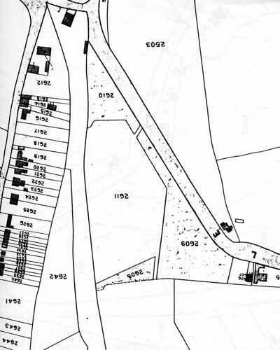
This building is actually two cottages, 101 Perry Vale (Swiss Cottage) and 103 Perry Vale (Dacres Cottage). You are quite right about their age, perryman, they were built in the early 1840s. They are older than the church you mention and are the oldest surviving buildings in that area.This map (dated 1843) shows the cottages. They are by the "E", at the lower right of the image:
The bend you mention is significant as it marked the point where Perry Vale ended, at the edge of Sydenham Common. This is best seen in this 1799 map:
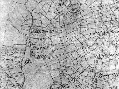
Perry Vale (then called Perry Slough, which tells us what it was like) is at the bottom. The edge of the common is marked by the line from Perry Vale to Stanstead Road. You can see the same line on the 1843 map and, in fact, it is still apparent on modern property boundaries including the part of Stanstead Road that is parallel to the railway line.
Incidentally, the cottages are listed. You can see the details <here>
The bend you mention is significant as it marked the point where Perry Vale ended, at the edge of Sydenham Common. This is best seen in this 1799 map:
Perry Vale (then called Perry Slough, which tells us what it was like) is at the bottom. The edge of the common is marked by the line from Perry Vale to Stanstead Road. You can see the same line on the 1843 map and, in fact, it is still apparent on modern property boundaries including the part of Stanstead Road that is parallel to the railway line.
Incidentally, the cottages are listed. You can see the details <here>
Curiouser and curiouser! (and sorry for the delay of thanks for detailed information.)
So the cottages have no obvious connection to a church despite their Gothic windows and crosses
and the date of 1797 refers to a time before it was built.
Presumably the date is connected to the mysterious black shields.
But fair enough, apologies due to the cottages as they are indeed historic buildings.
It puzzled me at first why they built the cottages right on the boundary path that ran from this point up to the Standsted Rd entrance to the common.
(You can just make the path out on the map of 1799.)
After all, they had the whole of the common to choose from, so why deliberately block a route and put (an already irritated by land reforms) people out of their way?
All I can think is that the parallel Westbourne Drive was already being planned,
and perhaps more importantly when a land owner provides a road, this service increases the price of the plots either side of it -
He will ensure that its his land on either side of the road.
So Perryman's latest theory is that generally the paths following the old boundary of the common are likely to be back gardens now or built on (like the site of 101 Perry Vale) .
Another example - Manor mount that fails to join up with the Westwood Pk/Honor Oak Rd junction, when the (admittedly implied rather than explicit on this map) boundary path would have cleanly met up with this common's entrance. The original Manor mt boundary path must be in the Manor mt back gardens.
I have some other observations/questions about that map of 1799, but they belong in another thread.
I'm clearly not qualified at all in these matters, so if I'm wrong, then I take no offence at all in being put in my place.
That map of 1799 is fascinating!
-
Steve Grindlay
- Posts: 606
- Joined: 4 Oct 2004 05:07
- Location: Upper Sydenham
Perryman, you are quite right about the line of the paths surviving as modern property boundaries. This map, the 1914 OS map, clearly shows the boundary of the common (and path) north from the cottages to Stanstead Road and beyond. The same line is still apparent today.
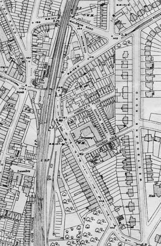
The map also explains why Hindsley's Place is a dead end and it clearly shows that Westbourne Road (Drive) consisted of large "middle-class" houses, while on the west side of the boundary there were tightly packed terraces. The Earl of Dartmouth developed the Westbourne Road houses, the terraces were the work of a speculative builder.
I don't agree with you over Manor Mount. In the 1843 tithe map all evidence of the edge of the common has been lost at this point. By this time, a single vast field, from London Road to Hill House, and Honor Oak Road to the railway line, belonged to one man, and was described as "pasture". Development of Manor Mount began about ten years later.
Another clue to boundaries are the many surviving ancient oaks in the area. These are often older than the houses that surround them, and can mark anything from field or property to parish or even county boundaries. The best of these are in Mayow Park. They mark field boundaries of the Old House estate, and are 250-300 years old.